


Le crest

gerauv
User
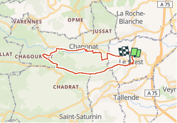

Length
14.4 km

Max alt
722 m

Uphill gradient
373 m
Km-Effort
19.3 km

Min alt
482 m

Downhill gradient
377 m
Boucle
Yes
Creation date :
2022-11-24 08:41:17.295
Updated on :
2022-11-24 14:17:05.453
5h35
Difficulty : Very difficult

FREE GPS app for hiking
 SityTrail
IGN / Geographical institutes
SityTrail Plus
The world is yours!
About
Trail Walking of 14.4 km to be discovered at Auvergne-Rhône-Alpes, Puy-de-Dôme, Le Crest. This trail is proposed by gerauv.
Positioning
Country:
France
Region :
Auvergne-Rhône-Alpes
Department/Province :
Puy-de-Dôme
Municipality :
Le Crest
Location:
Unknown
Start:(Dec)
Start:(UTM)
509845 ; 5059143 (31T) N.
Comments